The territory
controlled by India, the major portion of the Indian subcontinent, lies between
latitudes
6° and 36° N, and longitudes
68° and 98° E. The country sits atop the Indian
tectonic plate, a minor plate within the Indo-Australian
Plate.
India's defining geological processes commenced seventy-five million
years ago, when the Indian subcontinent, then part of the southern
supercontinent Gondwana,
began a northeastwards drift—lasting fifty million years—across the
then unformed Indian Ocean. The subcontinent's subsequent collision with the Eurasian Plate and subduction under it, gave
rise to the Himalayas,
the planet's highest mountains, which now abut India in the north
and the north-east. In the former seabed immediately
south of the emerging Himalayas, plate
movement created a vast trough, which, having gradually been filled
with river-borne sediment, now forms the Indo-Gangetic Plain.
To the west of this plain, and cut off from it by the Aravalli Range, lies the Thar Desert
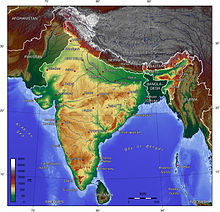 |
Topographic map of India.
India's coast is 7,517 kilometres (4,700 mi) long; of this
distance, 5,423 kilometres (3,400 mi) belong to peninsular India, and 2,094 kilometres (1,300 mi) to the Andaman,
Nicobar, and Lakshadweep
Islands. According to the
Indian naval hydrographic charts, the mainland coast consists of the following:
43% sandy beaches, 11% rocky coast including cliffs, and 46% mudflats
or marshy coast.
Major
Himalayan-origin rivers that substantially flow through India include the Ganges (Ganga)
the second largest river on the Indian subcontinent
by discharge. The 2,510 km (1,560 mi) river rises in
the western Himalayas
in the Indian state of Uttarakhand.
It has long been considered holy by Hindus and worshiped as the goddess Ganga in Hinduism. It has also been
important historically: many former provincial or imperial capitals (such as Patliputra,
Kannauj, Kara,
Allahabad, Murshidabad, Baharampur and Kolkata) have been located
on its banks. The Ganges Basin
drains 1,000,000-square-kilometre (390,000 sq mi) and supports one of the
world's highest densities of humans. The average depth of the river is 52 feet (16 m), and the maximum depth, 100 feet (30 m). And the Brahmaputra,
both of which drain into the Bay of Bengal. Important
tributaries of the Ganges include the Yamuna and the Kosi,
whose extremely low gradient causes disastrous floods every year.
  |
No hay comentarios:
Publicar un comentario